European Watershed — Geology & Trail

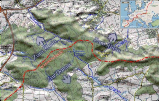
Map based on: Topographical Map 1:50 000, Nr. L 6526, L 6528
Reproduced with permission from Bayerisches Landesvermessungsamt München, Nr. 3159 / 04
Geological History
The European Watershed (or Continental Divide) crosses Europe from the south of Spain far into Russia. Rivers to the north drain into the Atlantic and the seas in its perimeter, while rivers to the south drain into the Mediterranean, Black and Caspian Seas. Within Germany the divide separates the tributaries of the Rhein (Rhine) and Donau (Danube) rivers.
The river Altmühl, which has its source in the south-eastern part of the Burgbernheim forest, flows with a gentle drop gradually toward the Danube — an ancient river in geological terms.
On the other side of the divide is the Tiefenbach creek with its source near the Wildbad. It belongs to the geologically younger system of the Rhine. With a steep drop its water flows first into the Aisch and then - via Regnitz and Main - into the Rhine. After just a few kilometers the little creek flows at the same elevation as the Altmühl does at its very end, where it joins the Danube. The ravine that the Tiefenbach has cut through the clay soil of the Frankenhöhe range is an indicator of its erosive force.
No less remarkable is the “stream capture” in progress at the “Hornauer Loch” (literally “the gap of Hornau”), where the drainage system of the Rhine is attacking the Danube system. Here another tributary of the Aisch has eaten a deep notch into the edge of the Frankenhöhe (the “gap”) and is in the process of tapping into the headwater region of the Altmühl. This battle for the watershed began millions of years ago, when the Aisch was clearing out the broad plain between the Steigerwald and Frankenhöhe ranges. It was then that it conquered the upper reaches of the proto-Altmühl that originally had run more to the north.

The European Watershed Trail curves in a large arc through the Nature Park „Frankenhӧhe“, criss-crossing areas whose rivers drain into the Black Sea and others who drain into the North Sea. Time and again its heights offer scenic views of the gentle landscape below. The entire trail runs 98 km (61 miles) between Ansbach and Schnelldorf. While sturdy walking shoes are recommended, the moderate changes in elevation are manageable even for beginners. It is an ideal trail for nature lovers, meandering through woodlands, meadows and pastures. Here the pleasure of walking, tranquility and seclusion together create a revitalizing experience.
It is these qualities that helped earn the European Watershed Trail a rating of excellence from the Deutscher Wanderverband, the national association of walking and mountaineering clubs. For more information see www.wasserscheideweg.de
